
Hurricane Hilary has rapidly intensified off Mexico's Pacific coast. While it will later weaken, Hilary's remnants will likely bring locally flooding rain and gusty winds to parts of California, including the Los Angeles Basin and Desert Southwest.
Here is what you need to know about this storm, its potential impacts and why it's taking this track.
Where Hilary is right now: Hilary is currently located several hundred miles to the southeast of Cabo San Lucas, Mexico, and is moving toward the west-northwest.
A tropical storm watch is in effect for the southern Baja California Peninsula, including Cabo San Lucas.
Where Hilary is headed and how strong it will become: Hilary rapidly intensified from a tropical storm to hurricane Wednesday into Thursday, and could top out at Category 4 intensity by Friday or Saturday. Fortunately, it will do that while it's still far from land.
Friday or Saturday, Hilary should take a subtle but important bend, taking it close to at least part of Mexico's Baja Peninsula. In a much weaker state, Hilary may track near or over parts of California early next week while transitioning into a post-tropical low-pressure system.
That means it will have lost characteristics of a tropical storm, but will still deliver potentially significant impacts to California and other parts of the Southwest.
 Hilary Forecast Path, Current Status
Why Hilary will weaken as it tracks farther north: Later this weekend or early next week, Hilary is expected to lose steam quickly.
A primary reason for this is that it will move over much cooler water once it moves past roughly the latitude of the southern tip of the Baja Peninsula.
Another reason is that Hilary's center could move over parts of the Baja Peninsula early next week.
Given those two factors, Hilary will likely be in a much weaker state by the time it nears or passes over parts of Southern California.
Never miss an update – get breaking news delivered straight to your desktop or mobile phone.
 Hilary Forecast Path, Water Temperatures
Impacts of its remnants and when may they arrive: Regardless of what meteorologists call it, Hilary's leftovers are likely to have several impacts in parts of the Southwest.
1. Locally heavy rain and flash flooding will become an increasing threat in Southern California and the Desert Southwest beginning this weekend, lasting into the first half of next week.
Some areas may see rounds of heavy downpours that can dump half an inch to an inch of rain or more in an hour, leading to flooding of normally dry creeks and arroyos. Landslides and mudslides are possible in a few areas, especially where at least moderate rainfall happens over areas recently burned by wildfires.
 Rainfall Outlook
2. High surf, coastal flooding and rip currents will also be a significant threat. The most dangerous flooding, including storm surge, is possible along parts of the southern Baja Peninsula, especially if Hilary's center comes ashore, and also along parts of the Gulf of California coast.
However, swells will also arrive along the coast of Southern California this weekend, and could last into Monday. These will likely impact south- and southeast-facing beaches the most, leading to dangerous high surf and perhaps some coastal flooding, especially at high tide.
3. Even if it's just the remnants of Hilary, some stronger wind gusts are possible in Southern California early next week that could lead to isolated power outages and tree damage.

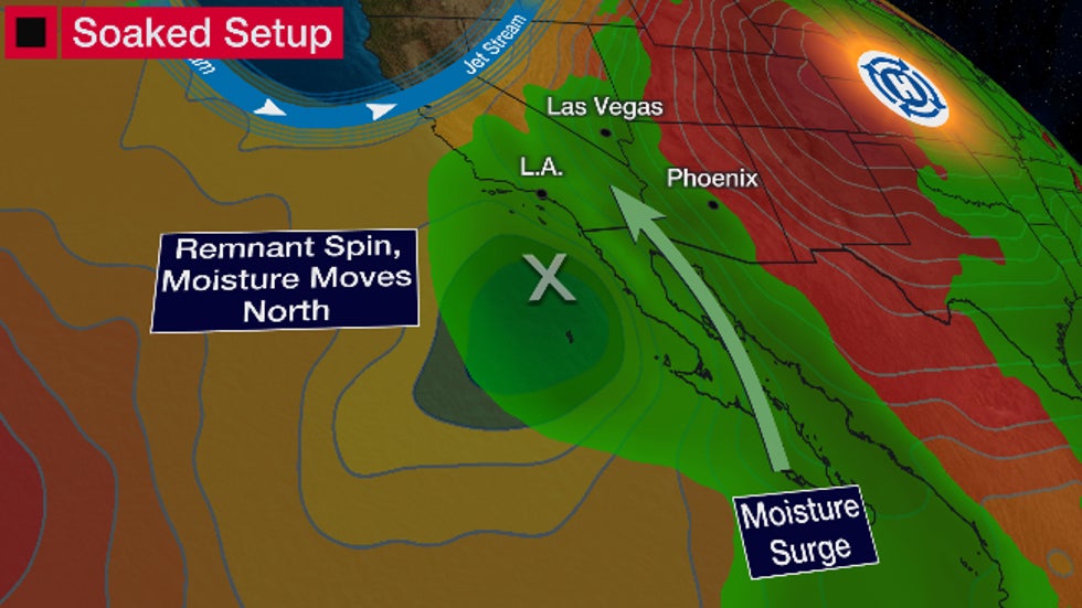
Why Hilary will move so far north: Most Eastern Pacific tropical storms and hurricanes form off the Mexican Pacific coast, then track over open water to the west and northwest and fizzle.
In this case, Hilary will be drawn northward because of the wind flow around a very strong "heat dome" of high pressure in the central U.S., together with a U-shaped trough of low pressure aloft near the West Coast.
In fact, some computer models suggest Hilary's remnant spin could be pulled as far north as Idaho or western Montana.
Hilary will also send a pulse of deep tropical moisture northward into not just the Desert Southwest, but potentially as far north as the Northern Rockies next week.
Why does this sound so familiar? Last week, the remnant of what was Tropical Storm Eugene dumped up to 1 inch of rain in parts of Southern California, a type of more widespread rain not common during the state's dry season.
Almost one year ago, Hurricane Kay also crawled northward along the southern Baja Peninsula before eventually fizzling south of the U.S.-Mexico border offshore.
While it never tracked into Southern California or the Southwest, Kay's remnants dumped up to 6 inches of rain in parts of the desert and high country of Southern California, leading to localized flash flooding, mudslides and debris flows.
Kay's remnants also produced wind gusts over 80 mph in the San Diego County mountains, which downed some trees and power lines in a few areas.
 Track history of Hurricane Kay in Sept. 2022. (Note: Black section of the line is when it was either a disturbance or a post-tropical remnant.)
Jonathan Erdman is a senior meteorologist at weather.com and has been an incurable weather geek since a tornado narrowly missed his childhood home in Wisconsin at age 7. Follow him on Twitter and Facebook.


.png)


.png)

0 Comments